Geolocate

Casma topographic map

Interactive map

Click on the map to display elevation.

About this map

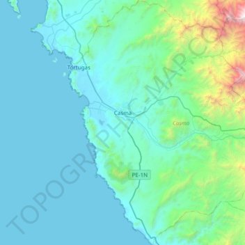
Name: Casma topographic map, elevation, terrain.

Location: Casma, Provincia de Casma, Áncash, Perú (-9.79485 -78.39836 -9.20092 -77.96482)

Average elevation: 1,312 ft

Minimum elevation: 0 ft

Maximum elevation: 13,346 ft

Other topographic maps

Click on a map to view its topography, its elevation and its terrain.

Carrizal

Perú > Áncash > Casma

Carrizal, Casma, Áncash, 02661, Perú

Average elevation: 299 ft

Nivin

Perú > Áncash > Casma

Nivin, Casma, Áncash, Perú

Average elevation: 1,348 ft

Santa Matilde

Perú > Áncash > Casma > San Francisco

Santa Matilde, San Francisco, Casma, Áncash, Perú

Average elevation: 456 ft

Sitio Arqueologico Chankillo

Perú > Áncash > Casma > Carrizal > Nivin

Sitio Arqueologico Chankillo, AN-1036, Nivin, Carrizal, Casma, Áncash, Perú

Average elevation: 659 ft

Río Sechín

Perú > Áncash > Casma

Río Sechín, Casma, Áncash, Perú

Average elevation: 397 ft