Geolocate

Dimapur topographic map

Click on the map to display elevation.

About this map

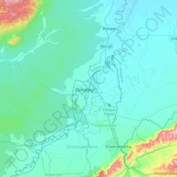
Name: Dimapur topographic map, elevation, terrain.

Location: Dimapur, Dimapur Sadar, Dimapur, Nagaland, 797112, India (25.75174 93.56170 26.07174 93.88170)

Average elevation: 669 ft

Minimum elevation: 410 ft

Maximum elevation: 2,526 ft

Gear up for your next adventure:

🪶Trail Camera - Capture wildlife on your hikes
🚪Portable Camp Chair - Foldable chair for comfort at camp
🎒Trekking Poles - Sturdy poles for balance and stability on rough terrain
🪶Paracord Bracelet - Survival bracelet with built‑in tools
Camping Coffee Makers - Enjoy premium coffee at the summit or campsite

As an Amazon Associate, this site earns from qualifying purchases at no extra cost to you.