
Limburg an der Lahn topographic map
Interactive map
Click on the map to display elevation.
About this map
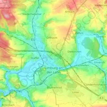
Name: Limburg an der Lahn topographic map, elevation, terrain.
Location: Limburg an der Lahn, Landkreis Limburg-Weilburg, Hesse, Germany (50.35699 7.98334 50.44590 8.15723)
Average elevation: 581 ft
Minimum elevation: 335 ft
Maximum elevation: 1,010 ft
The town lies roughly centrally in a basin within the Rhenish Slate Mountains which is surrounded by the low ranges of the Taunus and Westerwald and called the Limburg Basin (Limburger Becken). Owing to the favourable soil and climate, the Limburg Basin stands as one of Hesse's richest agricultural regions and moreover, with its convenient Lahn crossing, it has been of great importance to transport since the Middle Ages. Within the basin, the Lahn's otherwise rather narrow lower valley broadens out noticeably, making Limburg's mean elevation only 117 m above sea level.