
Plessis topographic map
Interactive map
Click on the map to display elevation.
About this map
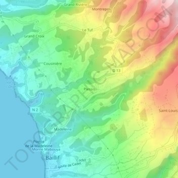
Name: Plessis topographic map, elevation, terrain.
Location: Plessis, Baillif, Basse-Terre, Guadeloupe, 97123, France (16.01792 -61.75678 16.05792 -61.71678)
Average elevation: 640 ft
Minimum elevation: 0 ft
Maximum elevation: 1,847 ft
Other topographic maps
Click on a map to view its topography, its elevation and its terrain.
Cadet
France > Guadeloupe > Baillif
Cadet, Baillif, Basse-Terre, Guadeloupe, 97123, France
Average elevation: 351 ft
Cité Lignères
France > Guadeloupe > Baillif
Cité Lignères, Baillif, Basse-Terre, Guadeloupe, 97123, France
Average elevation: 302 ft