
Municipio Roma X topographic map
Interactive map
Click on the map to display elevation.
About this map
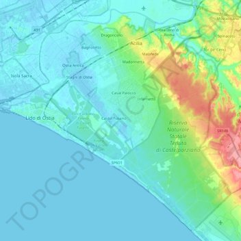
Name: Municipio Roma X topographic map, elevation, terrain.
Location: Municipio Roma X, Roma, RM, Lacio, Italia (41.65564 12.23447 41.80560 12.45145)
Average elevation: 56 ft
Minimum elevation: -10 ft
Maximum elevation: 325 ft
Other topographic maps
Click on a map to view its topography, its elevation and its terrain.
Municipio Roma I
Municipio Roma I, Roma, RM, Lacio, Italia
Average elevation: 167 ft