
Thank you for supporting this site ❤️
Make a donation
Make a donation
Gear up for your next adventure:
As an Amazon Associate, this site earns from qualifying purchases at no extra cost to you.
Erwitte topographic map
Click on the map to display elevation.
Thank you for supporting this site ❤️
Make a donation
Make a donation
Gear up for your next adventure:
As an Amazon Associate, this site earns from qualifying purchases at no extra cost to you.
About this map
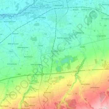
Name: Erwitte topographic map, elevation, terrain.
Location: Erwitte, Kreis Soest, North Rhine-Westphalia, 59597, Germany (51.57110 8.20007 51.64798 8.43138)
Average elevation: 443 ft
Minimum elevation: 223 ft
Maximum elevation: 1,050 ft
Thank you for supporting this site ❤️
Make a donation
Make a donation
Gear up for your next adventure:
As an Amazon Associate, this site earns from qualifying purchases at no extra cost to you.