
Make a donation
Gear up for your next adventure:
As an Amazon Associate, this site earns from qualifying purchases at no extra cost to you.
Aparan topographic map
Click on the map to display elevation.
Make a donation
Gear up for your next adventure:
As an Amazon Associate, this site earns from qualifying purchases at no extra cost to you.
Aparan
Modern-day Aparan is located at the eastern slopes of Mount Aragats and the northern slopes of Mount Ara, on the shores of Kasagh River, with an elevation of 1880 metres above sea level. The town is located at a road distance of 42 km north of Yerevan and 32 km north of the provincial capital Ashtarak, on the main north–south road of Armenia.
Make a donation
Gear up for your next adventure:
As an Amazon Associate, this site earns from qualifying purchases at no extra cost to you.
About this map
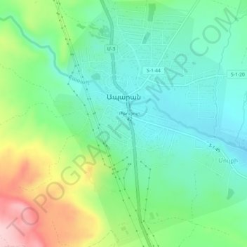
Name: Aparan topographic map, elevation, terrain.
Location: Aparan, Aparan community, Aragatsotn Province, 0301, Armenia (40.57036 44.34473 40.60425 44.37554)
Average elevation: 6,362 ft
Minimum elevation: 6,135 ft
Maximum elevation: 6,864 ft
Make a donation
Gear up for your next adventure:
As an Amazon Associate, this site earns from qualifying purchases at no extra cost to you.
Other topographic maps
Click on a map to view its topography, its elevation and its terrain.