
Thank you for supporting this site ❤️
Make a donation
Make a donation
Gear up for your next adventure:
As an Amazon Associate, this site earns from qualifying purchases at no extra cost to you.
Aiquile topographic map
Click on the map to display elevation.
Thank you for supporting this site ❤️
Make a donation
Make a donation
Gear up for your next adventure:
As an Amazon Associate, this site earns from qualifying purchases at no extra cost to you.
About this map
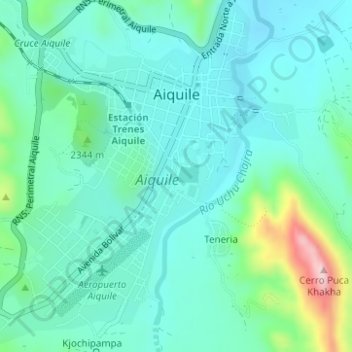
Name: Aiquile topographic map, elevation, terrain.
Location: Aiquile, Municipio Aiquile, Campero, Cochabamba, Bolivia (-18.22170 -65.20085 -18.19260 -65.16983)
Average elevation: 7,513 ft
Minimum elevation: 7,323 ft
Maximum elevation: 8,248 ft
Thank you for supporting this site ❤️
Make a donation
Make a donation
Gear up for your next adventure:
As an Amazon Associate, this site earns from qualifying purchases at no extra cost to you.