
Ibach topographic map
Interactive map
Click on the map to display elevation.
About this map
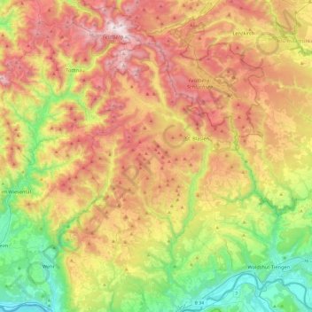
Name: Ibach topographic map, elevation, terrain.
Location: Ibach, Landkreis Waldshut, Baden-Württemberg, 79875, Duitsland (47.58169 7.90900 47.90169 8.22900)
Average elevation: 2,690 ft
Minimum elevation: 909 ft
Maximum elevation: 4,892 ft
Other topographic maps
Click on a map to view its topography, its elevation and its terrain.
Eggingen
Duitsland > Baden-Württemberg > Landkreis Waldshut
Eggingen, Verwaltungsgemeinschaft Wutöschingen, Landkreis Waldshut, Baden-Württemberg, 79805, Duitsland
Average elevation: 1,755 ft
Bad Säckingen
Duitsland > Baden-Württemberg > Landkreis Waldshut
Bad Säckingen, Verwaltungsgemeinschaft Bad Säckingen, Landkreis Waldshut, Baden-Württemberg, 79713, Duitsland
Average elevation: 1,437 ft
Rippoldsried
Duitsland > Baden-Württemberg > Landkreis Waldshut > Geroldshofstetten
Rippoldsried, Geroldshofstetten, Grafenhausen, Verwaltungsverband Oberes Schlüchttal, Landkreis Waldshut, Baden-Württemberg, 79865, Duitsland
Average elevation: 2,943 ft