
Bruce McLaren Memorial Park topographic map
Interactive map
Click on the map to display elevation.
About this map
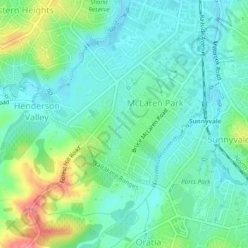
Name: Bruce McLaren Memorial Park topographic map, elevation, terrain.
Average elevation: 131 ft
Minimum elevation: 52 ft
Maximum elevation: 335 ft
Other topographic maps
Click on a map to view its topography, its elevation and its terrain.
Waimoko Glen
New Zealand > Auckland > Henderson-Massey
Waimoko Glen, Rānui, Henderson-Massey, Auckland, New Zealand
Average elevation: 151 ft
Lake Panorama
New Zealand > Auckland > Henderson-Massey
Lake Panorama, Western Heights, Henderson-Massey, Auckland, New Zealand
Average elevation: 171 ft