
Teotepeque topographic map
Interactive map
Click on the map to display elevation.
About this map
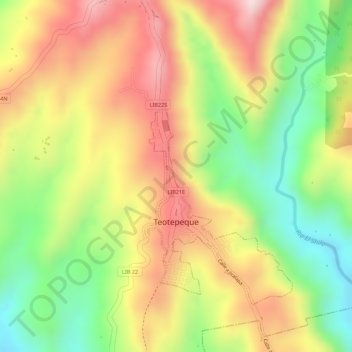
Name: Teotepeque topographic map, elevation, terrain.
Average elevation: 1,542 ft
Minimum elevation: 925 ft
Maximum elevation: 2,093 ft
Other topographic maps
Click on a map to view its topography, its elevation and its terrain.
Mizata
El Salvador > Departamento de La Libertad > Municipio de Teotepeque > Mizata
Mizata, Cantón Santa María Mizata, Municipio de Teotepeque, Departamento de La Libertad, El Salvador
Average elevation: 269 ft