
Budderoo National Park topographic map
Interactive map
Click on the map to display elevation.
About this map
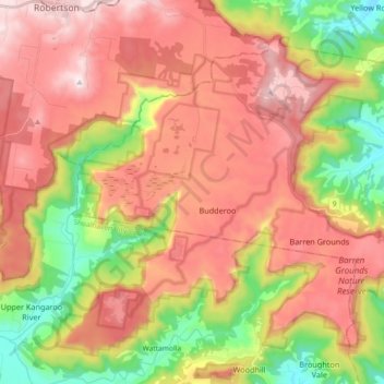
Name: Budderoo National Park topographic map, elevation, terrain.
Average elevation: 1,450 ft
Minimum elevation: 112 ft
Maximum elevation: 2,635 ft
Other topographic maps
Click on a map to view its topography, its elevation and its terrain.
Jamberoo
Australia > New South Wales > Jamberoo
Jamberoo, The Council of the Municipality of Kiama, New South Wales, 2533, Australia
Average elevation: 207 ft