
Vlas topographic map
Interactive map
Click on the map to display elevation.
About this map
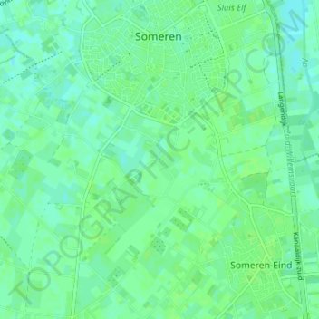
Name: Vlas topographic map, elevation, terrain.
Location: Vlas, Someren, Noord-Brabant, Nederland, 5712 XZ, Nederland (51.35036 5.69364 51.39036 5.73364)
Average elevation: 92 ft
Minimum elevation: 75 ft
Maximum elevation: 102 ft
Other topographic maps
Click on a map to view its topography, its elevation and its terrain.
Someren-Heide
Nederland > Noord-Brabant > Someren > Someren-Heide
Someren-Heide, Someren, Noord-Brabant, Nederland, 5712, Nederland
Average elevation: 92 ft
Someren-Eind
Nederland > Noord-Brabant > Someren
Someren-Eind, Someren, Noord-Brabant, Nederland, 5712 EM, Nederland
Average elevation: 92 ft