
Ilha topographic map
Interactive map
Click on the map to display elevation.
About this map
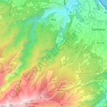
Name: Ilha topographic map, elevation, terrain.
Location: Ilha, Santana, Madeira, Portugal (32.75958 -16.95728 32.82177 -16.89646)
Average elevation: 2,441 ft
Minimum elevation: 0 ft
Maximum elevation: 5,988 ft
Other topographic maps
Click on a map to view its topography, its elevation and its terrain.
São Roque do Faial
São Roque do Faial, Santana, Madeira, Portugal
Average elevation: 2,073 ft
Praia de S. Jorge
Portugal > Santana > Calhau São Jorge
Praia de S. Jorge, Calhau, Calhau São Jorge, Santana, 9230-111, Portugal
Average elevation: 397 ft