
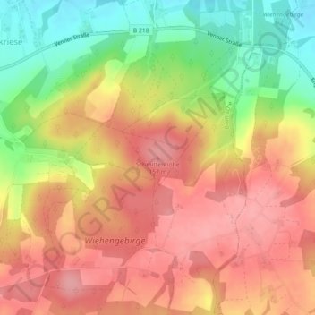
Schmittenhöhe topographic map
Interactive map
Click on the map to display elevation.
About this map
Name: Schmittenhöhe topographic map, elevation, terrain.
Average elevation: 387 ft
Minimum elevation: 171 ft
Maximum elevation: 531 ft
Other topographic maps
Click on a map to view its topography, its elevation and its terrain.
Engter
Duitsland > Nedersaksen > Landkreis Osnabrück > Bramsche
Engter, Bramsche, Landkreis Osnabrück, Nedersaksen, Duitsland
Average elevation: 285 ft
Achmer
Duitsland > Nedersaksen > Landkreis Osnabrück > Bramsche
Achmer, Bramsche, Landkreis Osnabrück, Nedersaksen, 49565, Duitsland
Average elevation: 190 ft