
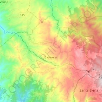
Cabeceras topographic map
Interactive map
Click on the map to display elevation.
About this map
Name: Cabeceras topographic map, elevation, terrain.
Average elevation: 3,314 ft
Minimum elevation: 1,411 ft
Maximum elevation: 5,646 ft
Other topographic maps
Click on a map to view its topography, its elevation and its terrain.
Santa Rosa
Santa Rosa, Cantón Tilarán, Provincia Guanacaste, 50804, Costa Rica
Average elevation: 1,627 ft
Tierras Morenas
Tierras Morenas, Cantón Tilarán, Provincia Guanacaste, 50806, Costa Rica
Average elevation: 2,119 ft
Tronadora
Tronadora, Cantón Tilarán, Provincia Guanacaste, 50803, Costa Rica
Average elevation: 2,343 ft