
Chaka topographic map
Interactive map
Click on the map to display elevation.
About this map
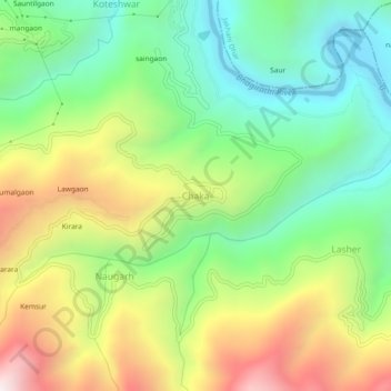
Name: Chaka topographic map, elevation, terrain.
Average elevation: 3,228 ft
Minimum elevation: 1,703 ft
Maximum elevation: 5,597 ft
Other topographic maps
Click on a map to view its topography, its elevation and its terrain.
Gaja
India > Uttarakhand > Narendra Nagar
Gaja, Narendra Nagar, Tehri Garhwal, Uttarakhand, India
Average elevation: 5,246 ft
Bagargaon
India > Uttarakhand > Narendra Nagar > Dagar
Bagargaon, Dagar, Narendra Nagar, Tehri Garhwal, Uttarakhand, 249175, India
Average elevation: 3,691 ft