
Pankow topographic map
Interactive map
Click on the map to display elevation.
About this map
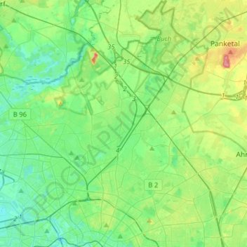
Name: Pankow topographic map, elevation, terrain.
Location: Pankow, Berlijn, Duitsland (52.51993 13.34756 52.67551 13.52302)
Average elevation: 174 ft
Minimum elevation: 95 ft
Maximum elevation: 377 ft
Other topographic maps
Click on a map to view its topography, its elevation and its terrain.
Siemensstadt
Siemensstadt, Spandau, Berlijn, 13629, Duitsland
Average elevation: 115 ft
Charlottenburg-Wilmersdorf
Charlottenburg-Wilmersdorf, Berlijn, Duitsland
Average elevation: 144 ft
Lichterfelde
Lichterfelde, Steglitz-Zehlendorf, Berlijn, Duitsland
Average elevation: 154 ft
Alt-Hohenschönhausen
Alt-Hohenschönhausen, Lichtenberg, Berlijn, Duitsland
Average elevation: 187 ft