
Oleye topographic map
Interactive map
Click on the map to display elevation.
About this map
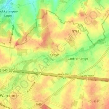
Name: Oleye topographic map, elevation, terrain.
Location: Oleye, Waremme, Liège, Wallonie, 4300, Belgique (50.69271 5.26085 50.73271 5.30085)
Average elevation: 381 ft
Minimum elevation: 289 ft
Maximum elevation: 440 ft
Other topographic maps
Click on a map to view its topography, its elevation and its terrain.
Petit-Axhe
Belgique > Liège > Waremme > Waremme
Petit-Axhe, Waremme, Liège, Wallonie, 4300, Belgique
Average elevation: 410 ft
Bovenistier
Belgique > Liège > Waremme > Waremme
Bovenistier, Waremme, Liège, Wallonie, 4300, Belgique
Average elevation: 456 ft