
Make a donation
Gear up for your next adventure:
As an Amazon Associate, this site earns from qualifying purchases at no extra cost to you.
Arez topographic map
Click on the map to display elevation.
Make a donation
Gear up for your next adventure:
As an Amazon Associate, this site earns from qualifying purchases at no extra cost to you.
Arez
The territory of Arês covers 115.407 square kilometers (44.559 sq mi), of which 2.728 square kilometres (1.053 sq mi) constitutes the urban area. It sits at an average altitude of 52 meters above sea level. Arês borders these municipalities: to the north, Nísia Floresta and São José de Mipibu; to the south, Goianinha and Tibau do Sul; to the east, Senador Georgino Avelino and Tibau do Sul again; and to the west, São José de Mipibu and Goianinha. The city is located 45 km from the state capital Natal, and 1,755 km from the federal capital Brasília.
Make a donation
Gear up for your next adventure:
As an Amazon Associate, this site earns from qualifying purchases at no extra cost to you.
About this map
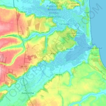
Name: Arez topographic map, elevation, terrain.
Average elevation: 115 ft
Minimum elevation: -7 ft
Maximum elevation: 387 ft
Make a donation
Gear up for your next adventure:
As an Amazon Associate, this site earns from qualifying purchases at no extra cost to you.
Other topographic maps
Click on a map to view its topography, its elevation and its terrain.