
Cádiz topographic map
Interactive map
Click on the map to display elevation.
About this map
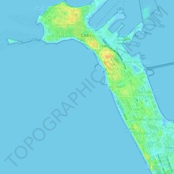
Name: Cádiz topographic map, elevation, terrain.
Location: Cádiz, Bahía de Cádiz, Cádiz, Andalucía, España (36.49518 -6.30818 36.53844 -6.26414)
Average elevation: 10 ft
Minimum elevation: -13 ft
Maximum elevation: 105 ft
Other topographic maps
Click on a map to view its topography, its elevation and its terrain.
Paseo de Canalejas
Paseo de Canalejas, Cádiz, Andalucía, España
Average elevation: 13 ft