
Plage de Caroual topographic map
Interactive map
Click on the map to display elevation.
About this map
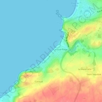
Name: Plage de Caroual topographic map, elevation, terrain.
Average elevation: 72 ft
Minimum elevation: -3 ft
Maximum elevation: 230 ft
Other topographic maps
Click on a map to view its topography, its elevation and its terrain.
Château de Bienassis
Château de Bienassis, Rue de la Libération, Erquy, Saint-Brieuc, Côtes-d'Armor, Bretagne, France métropolitaine, 22430, France
Average elevation: 299 ft
Plage du Centre
Plage du Centre, Boulevard de la Mer, Querbet, Erquy, Saint-Brieuc, Côtes-d'Armor, Bretagne, France métropolitaine, 22430, France
Average elevation: 85 ft