
West Midlands topographic map
Click on the map to display elevation.
About this map
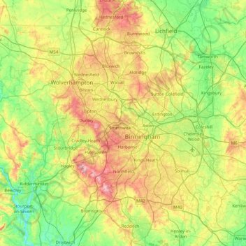
Name: West Midlands topographic map, elevation, terrain.
Average elevation: 371 ft
Minimum elevation: 49 ft
Maximum elevation: 1,007 ft
Other topographic maps
Click on a map to view its topography, its elevation and its terrain.
Burton Dassett Hills Country Park
United Kingdom > England > Warwickshire > Stratford-on-Avon > Northend > Burton Dassett CP
Average elevation: 433 ft
Shipston-on-Stour
United Kingdom > England > Warwickshire > Stratford-on-Avon
Average elevation: 272 ft
Wellesbourne
United Kingdom > England > Warwickshire > Stratford-on-Avon > Wellesbourne
Average elevation: 226 ft
Cranhill
United Kingdom > England > Warwickshire > Stratford-on-Avon > Ardens Grafton
Average elevation: 187 ft