
Make a donation
Gear up for your next adventure:
As an Amazon Associate, this site earns from qualifying purchases at no extra cost to you.
Twin Bridges topographic map
Click on the map to display elevation.
Make a donation
Gear up for your next adventure:
As an Amazon Associate, this site earns from qualifying purchases at no extra cost to you.
About this map
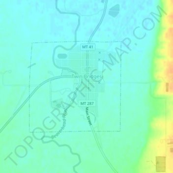
Name: Twin Bridges topographic map, elevation, terrain.
Location: Twin Bridges, Madison County, Montana, United States (45.53562 -112.34389 45.54984 -112.32344)
Average elevation: 4,639 ft
Minimum elevation: 4,613 ft
Maximum elevation: 4,711 ft
Madison County trails, hiking, mountain biking, running and outdoor activities
Make a donation
Gear up for your next adventure:
As an Amazon Associate, this site earns from qualifying purchases at no extra cost to you.
Other topographic maps
Click on a map to view its topography, its elevation and its terrain.
Make a donation
Gear up for your next adventure:
As an Amazon Associate, this site earns from qualifying purchases at no extra cost to you.
Big Sky Dam
United States > Montana > Madison County > Big Sky > Big Sky Mountain Village
Average elevation: 7,726 ft
Make a donation
Gear up for your next adventure:
As an Amazon Associate, this site earns from qualifying purchases at no extra cost to you.