
Barabe topographic map
Interactive map
Click on the map to display elevation.
About this map
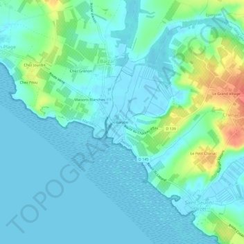
Name: Barabe topographic map, elevation, terrain.
Average elevation: 39 ft
Minimum elevation: -3 ft
Maximum elevation: 190 ft
Other topographic maps
Click on a map to view its topography, its elevation and its terrain.
Saint-Seurin-d'Uzet
France > Nouvelle-Aquitaine > Charente-Maritime > Chenac-Saint-Seurin-d'Uzet
Saint-Seurin-d'Uzet, Chenac-Saint-Seurin-d'Uzet, Saintes, Charente-Maritime, Nouvelle-Aquitaine, France métropolitaine, 17120, France
Average elevation: 46 ft