
Planfayon topographic map
Interactive map
Click on the map to display elevation.
About this map
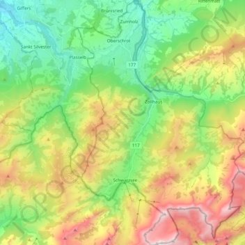
Name: Planfayon topographic map, elevation, terrain.
Location: Planfayon, District de la Singine, Fribourg, 1716, Suisse (46.63570 7.25118 46.76553 7.38027)
Average elevation: 4,098 ft
Minimum elevation: 2,188 ft
Maximum elevation: 7,270 ft
Other topographic maps
Click on a map to view its topography, its elevation and its terrain.
Plasselb
Suisse > Fribourg > District de la Singine
Plasselb, District de la Singine, Fribourg, 1737, Suisse
Average elevation: 3,698 ft
Lac Noir
Suisse > Fribourg > District de la Singine > Lac Noir
Lac Noir, Lenggera, Lac Noir, Planfayon, District de la Singine, Fribourg, 1716, Suisse
Average elevation: 4,032 ft
Chevrilles
Suisse > Fribourg > District de la Singine
Chevrilles, District de la Singine, Fribourg, 1735, Suisse
Average elevation: 2,543 ft