
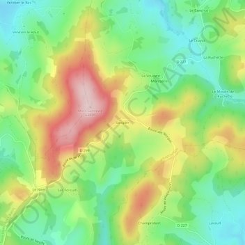
Sanglier topographic map
Interactive map
Click on the map to display elevation.
About this map
Name: Sanglier topographic map, elevation, terrain.
Average elevation: 1,509 ft
Minimum elevation: 1,122 ft
Maximum elevation: 2,073 ft
Other topographic maps
Click on a map to view its topography, its elevation and its terrain.
Le Puits
Frankrijk > Bourgondië-Franche-Comté > Nièvre > Villapourçon
Le Puits, Villapourçon, Château-Chinon (Ville), Nièvre, Bourgondië-Franche-Comté, Metropolitaans Frankrijk, 58370, Frankrijk
Average elevation: 1,854 ft
La Foret
Frankrijk > Bourgondië-Franche-Comté > Nièvre > Villapourçon > Le Croyot
La Foret, Le Croyot, Villapourçon, Château-Chinon (Ville), Nièvre, Bourgondië-Franche-Comté, Metropolitaans Frankrijk, 58370, Frankrijk
Average elevation: 1,414 ft