
Tuxford topographic map
Interactive map
Click on the map to display elevation.
About this map
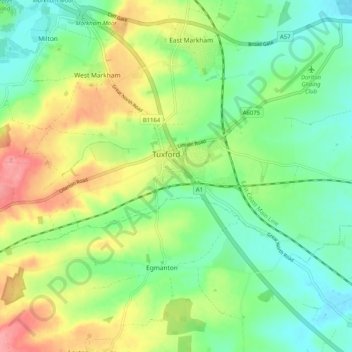
Name: Tuxford topographic map, elevation, terrain.
Location: Tuxford, Bassetlaw, Nottinghamshire, England, United Kingdom (53.21218 -0.94974 53.24220 -0.84764)
Average elevation: 154 ft
Minimum elevation: 52 ft
Maximum elevation: 318 ft
Other topographic maps
Click on a map to view its topography, its elevation and its terrain.
Hallcroft
United Kingdom > England > Nottinghamshire > Bassetlaw > Retford
Hallcroft, Retford, Bassetlaw, Nottinghamshire, England, United Kingdom, Snake Lake
Average elevation: 56 ft
Sturton le Steeple
United Kingdom > England > Nottinghamshire > Bassetlaw
Sturton le Steeple, Bassetlaw, Nottinghamshire, England, DN22 9HW, United Kingdom
Average elevation: 52 ft