
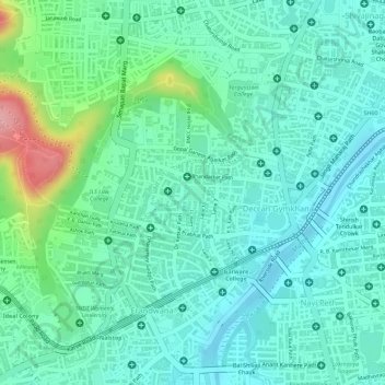
Kamala Nehru Park topographic map
Interactive map
Click on the map to display elevation.
About this map
Name: Kamala Nehru Park topographic map, elevation, terrain.
Average elevation: 1,893 ft
Minimum elevation: 1,775 ft
Maximum elevation: 2,228 ft
Other topographic maps
Click on a map to view its topography, its elevation and its terrain.
Sinhagad Vikas Udyan
India > Maharashtra > Pune
Sinhagad Vikas Udyan, Vadgaon Budruk, Pune, Pune District, Maharashtra, 411051, India
Average elevation: 1,903 ft
Sangamwadi
India > Maharashtra > Pune
Sangamwadi, Pune, Maharashtra, 411001, India
Average elevation: 1,811 ft
Phulenagar
India > Maharashtra > Pune > Khadki
Phulenagar, Ward 16, Khadki, Pune, Pune District, Maharashtra, 411001, India
Average elevation: 1,827 ft
Koregaon Park
India > Maharashtra > Pune
Koregaon Park, Suyojan Society, Ghorpuri, Pune, Maharashtra, 411001, India
Average elevation: 1,821 ft
Katraj Lake
India > Maharashtra > Pune > Katraj
Katraj Lake, Katraj, Pune, Maharashtra, 411046, India
Average elevation: 2,172 ft
Indrayani
India > Maharashtra > Pune
Indrayani, Pune, Maharashtra, 411001, India
Average elevation: 2,224 ft
Udaan Biodiversity Park
India > Maharashtra > Pune
Udaan Biodiversity Park, Ward 6, Pune, Maharashtra, 411014, India
Average elevation: 1,877 ft
Mula-Mutha River
India > Maharashtra > Pune
Mula-Mutha River, Ghorpuri, Pune, Maharashtra, India
Average elevation: 1,824 ft
Chittranjan Vatika
India > Maharashtra > Pune
Chittranjan Vatika, Electoral Ward 14, Model Colony, Pune, Maharashtra, India
Average elevation: 1,883 ft
Vetal Tekdi
India > Maharashtra > Pune
Vetal Tekdi, Pune, Maharashtra, 411053, India
Average elevation: 2,041 ft
Shaniwarwada
India > Maharashtra > Pune
Shaniwarwada, Shivaji Road, Kasba Peth, Pune, Pune City, Pune, Maharashtra, 411001, India
Average elevation: 1,837 ft
Karha River
India > Maharashtra > Pune
Karha River, Pune, Maharashtra, 411001, India
Average elevation: 2,139 ft
Temghar dam
India > Maharashtra > Pune
Temghar dam, Pune, Maharashtra, 411001, India
Average elevation: 2,444 ft
Chaskaman
India > Maharashtra > Pune
Chaskaman, Pune, Maharashtra, 411001, India
Average elevation: 2,192 ft
Kondhwa Budruk
India > Maharashtra > Pune
Kondhwa Budruk, Pune, Pune District, Maharashtra, 411048, India
Average elevation: 2,152 ft
Bhama Askhed
India > Maharashtra > Pune
Bhama Askhed, Khed, Pune District, Maharashtra, India
Average elevation: 2,195 ft
Khadki
India > Maharashtra > Pune
Khadki, Pune, Pune District, Maharashtra, 411003, India
Average elevation: 1,854 ft
Lokmanya Nagar
India > Maharashtra > Pune
Lokmanya Nagar, Pune, Maharashtra, 411001, India
Average elevation: 1,867 ft