
West Ocean City topographic map
Interactive map
Click on the map to display elevation.
About this map
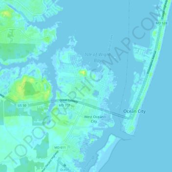
Name: West Ocean City topographic map, elevation, terrain.
Location: West Ocean City, Worcester County, Maryland, United States (38.30891 -75.13410 38.38230 -75.09310)
Average elevation: 7 ft
Minimum elevation: -20 ft
Maximum elevation: 52 ft
Other topographic maps
Click on a map to view its topography, its elevation and its terrain.
Assateague Island National Seashore
United States > Maryland > Worcester County > West Ocean City
Assateague Island National Seashore, West Ocean City, Worcester County, Maryland, United States
Average elevation: 7 ft