
Crawinkel topographic map
Interactive map
Click on the map to display elevation.
About this map
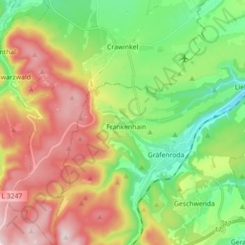
Name: Crawinkel topographic map, elevation, terrain.
Location: Crawinkel, Ohrdruf, Landkreis Gotha, Thüringen, Deutschland (50.71792 10.72425 50.79626 10.82820)
Average elevation: 1,759 ft
Minimum elevation: 1,201 ft
Maximum elevation: 2,526 ft
Zu Crawinkel bemerkt Galletti in seiner topographisch-historischen Beschreibung des Gothaer Herzogtums von 1780:
Other topographic maps
Click on a map to view its topography, its elevation and its terrain.
Wölfis
Deutschland > Thüringen > Landkreis Gotha > Ohrdruf
Wölfis, Ohrdruf, Landkreis Gotha, Thüringen, 99885, Deutschland
Average elevation: 1,453 ft