
Miélan topographic map
Interactive map
Click on the map to display elevation.
About this map
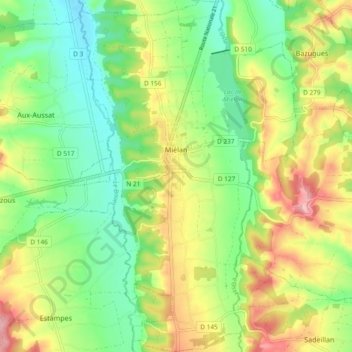
Name: Miélan topographic map, elevation, terrain.
Average elevation: 817 ft
Minimum elevation: 617 ft
Maximum elevation: 1,112 ft
La superficie de la commune est de 2 188 hectares. Son altitude varie de 187 à 303 mètres.
Other topographic maps
Click on a map to view its topography, its elevation and its terrain.
Saint-Mézard
Saint-Mézard, Condom, Gers, Occitanie, France métropolitaine, 32700, France
Average elevation: 479 ft
Luppé-Violles
Luppé-Violles, Condom, Gers, Occitanie, France métropolitaine, 32110, France
Average elevation: 430 ft
Bellegarde
Bellegarde, Mirande, Gers, Occitanie, France métropolitaine, 32140, France
Average elevation: 840 ft
Saint-Antonin
France > Occitanie > Gers > Saint-Antonin
Saint-Antonin, Condom, Gers, Occitanie, France métropolitaine, 32120, France
Average elevation: 574 ft
Saint-Justin
Saint-Justin, Mirande, Gers, Occitanie, France métropolitaine, 32230, France
Average elevation: 614 ft