
San Francisco de Macorís topographic map
Interactive map
Click on the map to display elevation.
About this map
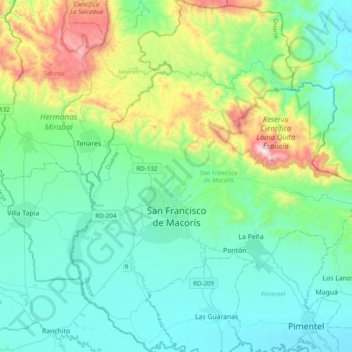
Name: San Francisco de Macorís topographic map, elevation, terrain.
Location: San Francisco de Macorís, Duarte, Dominican Republic (19.15534 -70.37104 19.52266 -70.01446)
Average elevation: 715 ft
Minimum elevation: 82 ft
Maximum elevation: 3,143 ft
The relief of Duarte Province ranges from 17 to 942 metres (56 to 3,091 ft) above sea level, reaching its highest elevation at "Loma Quita Espuela". This name allegedly comes from the time when the Spaniards were exploring the island, since the hill was too steep to ride their horses, they had to dismount and remove their spurs and undertake the ascent on foot. There are two main geologic regions: the north slope of the Cordillera Septentrional and the rough topography of the Delta del Yuna.
Other topographic maps
Click on a map to view its topography, its elevation and its terrain.
Barrio De Chulin
Dominican Republic > Duarte > Pimentel > Barrio De Chulin
Barrio De Chulin, Pimentel, Duarte, 33000, Dominican Republic
Average elevation: 131 ft