
Peña del Palomar topographic map
Interactive map
Click on the map to display elevation.
About this map
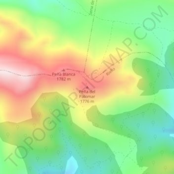
Name: Peña del Palomar topographic map, elevation, terrain.
Location: Peña del Palomar, Riello, León, Castilla y León, España (42.86429 -5.95012 42.86439 -5.95002)
Average elevation: 5,148 ft
Minimum elevation: 4,449 ft
Maximum elevation: 6,083 ft
Other topographic maps
Click on a map to view its topography, its elevation and its terrain.
La Urz
España > Castilla y León > Riello
La Urz, Riello, León, Castilla y León, 24127, España
Average elevation: 4,055 ft
Villarubia
España > Castilla y León > Riello > Manzaneda de Omaña
Villarubia, Manzaneda de Omaña, Riello, León, Castilla y León, España
Average elevation: 4,121 ft
Piedra Hincada
España > Castilla y León > Riello
Piedra Hincada, Riello, León, Castilla y León, España
Average elevation: 5,131 ft