
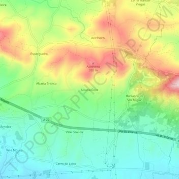
Alcaria Cova topographic map
Interactive map
Click on the map to display elevation.
About this map
Name: Alcaria Cova topographic map, elevation, terrain.
Location: Alcaria Cova, Conceição e Estoi, Faro, 8005-405, Portugal (37.07989 -7.87913 37.11989 -7.83913)
Average elevation: 594 ft
Minimum elevation: 200 ft
Maximum elevation: 1,214 ft
Other topographic maps
Click on a map to view its topography, its elevation and its terrain.
Bela Curral
Bela Curral, Conceição e Estoi, Faro, 8005-418, Portugal
Average elevation: 98 ft
Areal Gordo
Areal Gordo, Faro (Sé e São Pedro), Faro, 8005-409, Portugal
Average elevation: 62 ft
Santa Bárbara de Nexe
Santa Bárbara de Nexe, Faro, Portugal
Average elevation: 525 ft
Quinta das Raposeiras
Portugal > Faro > Faro > Quinta das Raposeiras
Quinta das Raposeiras, Santa Bárbara de Nexe, Faro, 8005-423, Portugal
Average elevation: 840 ft
Praia da Ilha de Faro
Portugal > Faro > Faro > Almancil
Praia da Ilha de Faro, Almancil, Faro, Loulé, Faro, Portugal
Average elevation: 3 ft