
Denny Mountain topographic map
Interactive map
Click on the map to display elevation.
About this map
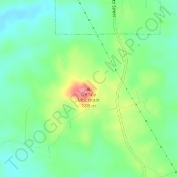
Name: Denny Mountain topographic map, elevation, terrain.
Location: Denny Mountain, Nacogdoches County, Texas, 75760, USA (31.79512 -94.84388 31.79522 -94.84378)
Average elevation: 449 ft
Minimum elevation: 358 ft
Maximum elevation: 623 ft
Other topographic maps
Click on a map to view its topography, its elevation and its terrain.
Horseshoe Bay
USA > Texas > Horseshoe Bay
Horseshoe Bay, Llano County, Texas, 78657, USA
Average elevation: 938 ft
Post Oak Ridge
USA > Texas > Lago Vista
Post Oak Ridge, Lago Vista, Travis County, Texas, 78645, USA
Average elevation: 1,030 ft
Fish Bay
USA > Texas > Berryville
Fish Bay, Wheel Estate Road, Berryville, Henderson County, Texas, 75763, USA
Average elevation: 361 ft
San Jacinto Mountain
San Jacinto Mountain, Presidio County, Texas, USA
Average elevation: 4,045 ft
Cranes Mill
USA > Texas > Cranes Mill
Cranes Mill, Comal County, Texas, USA
Average elevation: 1,184 ft
Guadalupe Peak
Guadalupe Peak, Culberson County, Texas, 79847, USA
Average elevation: 7,057 ft
Karnes City
USA > Texas > Karnes City
Karnes City, Karnes County, Texas, 78118, USA
Average elevation: 400 ft
Towne Lake
USA > Texas > Towne Lake
Towne Lake, Harris County, Texas, 77433, USA
Average elevation: 144 ft
Chinati Mountains State Park
Chinati Mountains State Park, Presidio County, Texas, USA
Average elevation: 4,075 ft