
Arnsberg topographic map
Interactive map
Click on the map to display elevation.
About this map
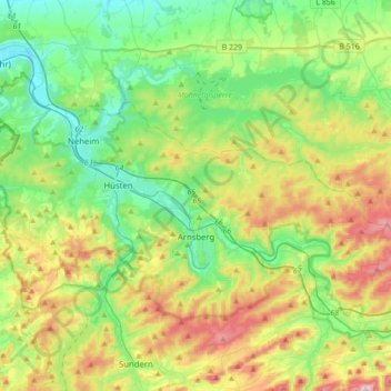
Name: Arnsberg topographic map, elevation, terrain.
Average elevation: 922 ft
Minimum elevation: 449 ft
Maximum elevation: 1,896 ft
Other topographic maps
Click on a map to view its topography, its elevation and its terrain.
Winterberg
Allemagne > Rhénanie-du-Nord-Westphalie > Hochsauerlandkreis > Winterberg > Winterberg
Winterberg, Hochsauerlandkreis, Rhénanie-du-Nord-Westphalie, 59955, Allemagne
Average elevation: 2,126 ft
Winterberg
Allemagne > Rhénanie-du-Nord-Westphalie > Hochsauerlandkreis
Winterberg, Hochsauerlandkreis, Rhénanie-du-Nord-Westphalie, 59955, Allemagne
Average elevation: 2,057 ft
Schmallenberg
Allemagne > Rhénanie-du-Nord-Westphalie > Hochsauerlandkreis
Schmallenberg, Hochsauerlandkreis, Rhénanie-du-Nord-Westphalie, 57392, Allemagne
Average elevation: 1,677 ft