
La Cluse topographic map
Interactive map
Click on the map to display elevation.
About this map
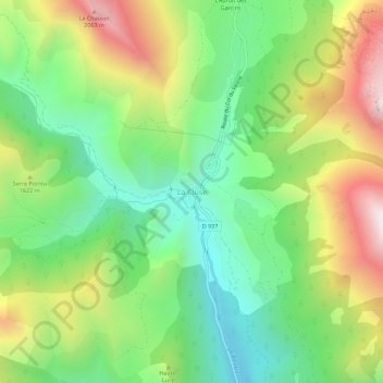
Name: La Cluse topographic map, elevation, terrain.
Average elevation: 4,954 ft
Minimum elevation: 3,619 ft
Maximum elevation: 7,054 ft
Other topographic maps
Click on a map to view its topography, its elevation and its terrain.
La Joue du Loup
Frankrijk > Provence-Alpes-Côte d'Azur > Hautes-Alpes > Le Dévoluy
La Joue du Loup, Agnières-en-Dévoluy, Le Dévoluy, Gap, Hautes-Alpes, Provence-Alpes-Côte d'Azur, Metropolitaans Frankrijk, 05250, Frankrijk
Average elevation: 4,882 ft