
Casa Cañete topographic map
Interactive map
Click on the map to display elevation.
About this map
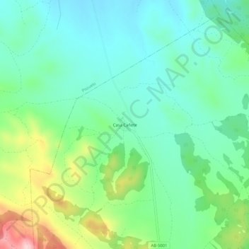
Name: Casa Cañete topographic map, elevation, terrain.
Average elevation: 2,841 ft
Minimum elevation: 2,635 ft
Maximum elevation: 3,360 ft
Other topographic maps
Click on a map to view its topography, its elevation and its terrain.
La Solana
España > Castilla-La Mancha > Peñas de San Pedro
La Solana, Peñas de San Pedro, Albacete, Castilla-La Mancha, España
Average elevation: 3,136 ft