Conchas Lake topographic map
Interactive map
Click on the map to display elevation.
About this map
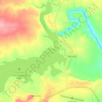
Name: Conchas Lake topographic map, elevation, terrain.
Average elevation: 4,216 ft
Minimum elevation: 4,029 ft
Maximum elevation: 4,413 ft

Click on the map to display elevation.
Name: Conchas Lake topographic map, elevation, terrain.
Average elevation: 4,216 ft
Minimum elevation: 4,029 ft
Maximum elevation: 4,413 ft