
La Gouile topographic map
Interactive map
Click on the map to display elevation.
About this map
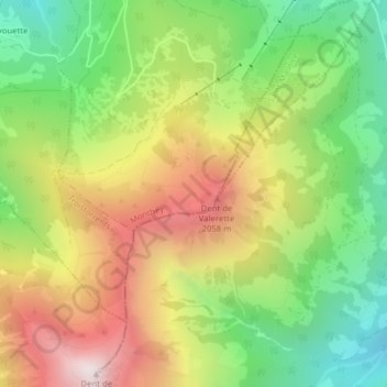
Name: La Gouile topographic map, elevation, terrain.
Location: La Gouile, Route du Milieu, Monthey, Vallese, 1871, Svizzera (46.20747 6.94973 46.20792 6.95029)
Average elevation: 5,279 ft
Minimum elevation: 3,533 ft
Maximum elevation: 7,411 ft
Other topographic maps
Click on a map to view its topography, its elevation and its terrain.
Tête du Géant
Tête du Géant, Monthey, Vallese, 1875, Svizzera
Average elevation: 5,948 ft
Pointe de Chésery
Pointe de Chésery, Monthey, Vallese, Svizzera
Average elevation: 6,181 ft