
Oxie topographic map
Interactive map
Click on the map to display elevation.
About this map
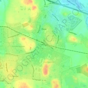
Name: Oxie topographic map, elevation, terrain.
Location: Oxie, Malmö kommun, Skåne County, Region Götaland, Sweden (55.52821 13.06701 55.55435 13.11767)
Average elevation: 135 ft
Minimum elevation: 72 ft
Maximum elevation: 197 ft
In the late 19th and early 20th century, the village expanded with the establishment of several brick and gravel industries. Remains from this era can still be seen in the topography of Oxie. For example, the ponds Kvistadammarna, are the remaining digs from where Djurbergs brick factory extracted clay. Like in many other small, rural communities this rapid industrialisation was facilitated by the establishment of railroad communications.