
Vila Alva topographic map
Interactive map
Click on the map to display elevation.
About this map
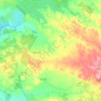
Name: Vila Alva topographic map, elevation, terrain.
Location: Vila Alva, Cuba, Beja, Portugal (38.21934 -7.93661 38.28478 -7.84326)
Average elevation: 748 ft
Minimum elevation: 505 ft
Maximum elevation: 1,066 ft
Other topographic maps
Click on a map to view its topography, its elevation and its terrain.
Faro do Alentejo
Faro do Alentejo, Cuba, Beja, 7940-311, Portugal
Average elevation: 581 ft