
Tamasopo topographic map
Interactive map
Click on the map to display elevation.
About this map
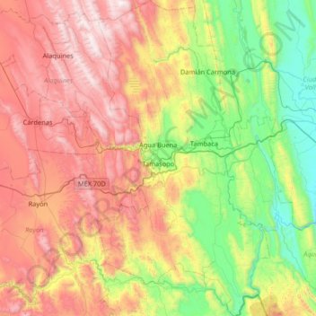
Name: Tamasopo topographic map, elevation, terrain.
Location: Tamasopo, San Luis Potosí, 79700, México (21.62887 -99.52060 22.23368 -99.16318)
Average elevation: 2,297 ft
Minimum elevation: 138 ft
Maximum elevation: 5,837 ft
Other topographic maps
Click on a map to view its topography, its elevation and its terrain.
Agua Buena
México > San Luis Potosí > Tamasopo
Agua Buena, Tamasopo, San Luis Potosí, 79700, México
Average elevation: 1,749 ft