
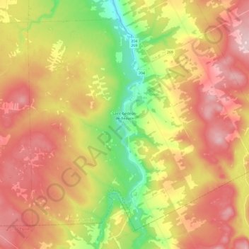
Saint-Gédéon-de-Beauce topographic map
Interactive map
Click on the map to display elevation.
About this map
Name: Saint-Gédéon-de-Beauce topographic map, elevation, terrain.
Average elevation: 1,227 ft
Minimum elevation: 755 ft
Maximum elevation: 1,654 ft
Other topographic maps
Click on a map to view its topography, its elevation and its terrain.
La Guadeloupe
Canada > Québec > Beauce-Sartigan
La Guadeloupe, Beauce-Sartigan, Chaudière-Appalaches, Québec, G0M 1G0, Canada
Average elevation: 1,079 ft
Saint-Côme–Linière
Canada > Québec > Beauce-Sartigan
Saint-Côme–Linière, Beauce-Sartigan, Chaudière-Appalaches, Québec, G0M 1J0, Canada
Average elevation: 1,096 ft