
Kuttapalayam topographic map
Interactive map
Click on the map to display elevation.
About this map
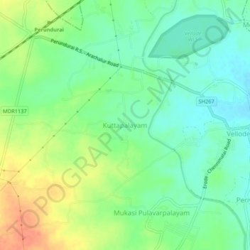
Name: Kuttapalayam topographic map, elevation, terrain.
Average elevation: 833 ft
Minimum elevation: 774 ft
Maximum elevation: 919 ft
Other topographic maps
Click on a map to view its topography, its elevation and its terrain.
Vijayamangalam
India > Tamil Nadu > Perundurai
Vijayamangalam, Perundurai, Erode District, Tamil Nadu, 638056, India
Average elevation: 974 ft
Chennimalai
India > Tamil Nadu > Perundurai
Chennimalai, Perundurai, Erode District, Tamil Nadu, 638051, India
Average elevation: 876 ft
Perundurai
India > Tamil Nadu > Perundurai
Perundurai, Erode District, Tamil Nadu, India
Average elevation: 866 ft