
Amatrice topographic map
Interactive map
Click on the map to display elevation.
About this map
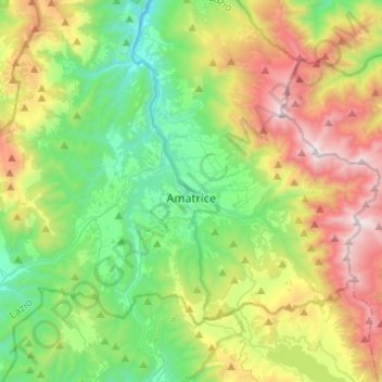
Name: Amatrice topographic map, elevation, terrain.
Location: Amatrice, Rieti, Latium, 02012, Italien (42.56956 13.16519 42.69521 13.40998)
Average elevation: 4,285 ft
Minimum elevation: 2,290 ft
Maximum elevation: 8,009 ft
Amatrice liegt 138 km nordöstlich von Rom und 63 km nördlich von Rieti. Der Ort liegt im oberen Tal des Tronto, an der Via Salaria am Fuß der Monti della Laga. Auf dem Gebiet der Gemeinde, zu der etwa 70 kleine Weiler gehören, liegt in beherrschender Lage der Gipfel des Monte Gorzano (2458 m s.l.m.), des höchsten Bergs von Latium. Unterhalb des auf einem Felssporn liegenden Zentrums liegt der Lago di Scandarello, ein Stausee. Das Gemeindegebiet erstreckt sich über eine Höhe von 750 m s.l.m. bis 2458 m s.l.m.
Other topographic maps
Click on a map to view its topography, its elevation and its terrain.
Poggio
Italien > Latium > Rieti > Roccantica
Poggio, Roccantica, Rieti, Latium, 02047, Italien
Average elevation: 1,155 ft
Monte San Giovanni in Sabina
Monte San Giovanni in Sabina, Rieti, Latium, Italien
Average elevation: 2,375 ft