
Glen Forest topographic map
Interactive map
Click on the map to display elevation.
About this map
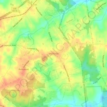
Name: Glen Forest topographic map, elevation, terrain.
Location: Glen Forest, Durham County, North Carolina, United States (36.00209 -78.82973 36.04209 -78.78973)
Average elevation: 331 ft
Minimum elevation: 253 ft
Maximum elevation: 390 ft
Other topographic maps
Click on a map to view its topography, its elevation and its terrain.
Durham
United States > North Carolina > Durham County > Durham
Durham, Durham County, North Carolina, 27701, United States
Average elevation: 390 ft
Durham
United States > North Carolina > Durham County
Durham, Durham County, North Carolina, United States
Average elevation: 384 ft