
Insel topographic map
Interactive map
Click on the map to display elevation.
About this map
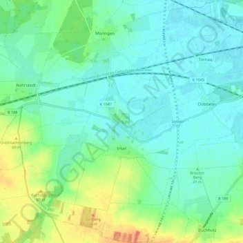
Name: Insel topographic map, elevation, terrain.
Location: Insel, Stendal, Sachsen-Anhalt, Deutschland (52.53572 11.70296 52.60209 11.81227)
Average elevation: 144 ft
Minimum elevation: 105 ft
Maximum elevation: 246 ft
Insel, ein Dorf mit Kirche, liegt etwa 10 km von Stendal entfernt in der Altmark. Das Gelände fällt vom Tangermünder-Buchholzer Höhenzug in Richtung Norden zur Uchteniederung ab. Nördlich von Insel liegt die ehemalige Kiesgrube Hillberg.
Other topographic maps
Click on a map to view its topography, its elevation and its terrain.
Schnöggersburg (Wüstung)
Deutschland > Sachsen-Anhalt > Stendal > Stendal > Staats
Schnöggersburg (Wüstung), Staats, Stendal, Sachsen-Anhalt, 39576, Deutschland
Average elevation: 328 ft
Bockelberg
Deutschland > Sachsen-Anhalt > Stendal > Stendal
Bockelberg, Stendal, Sachsen-Anhalt, Deutschland
Average elevation: 348 ft
Süd
Deutschland > Sachsen-Anhalt > Stendal > Stendal
Süd, Stendal, Sachsen-Anhalt, Deutschland
Average elevation: 115 ft
Möringen
Deutschland > Sachsen-Anhalt > Stendal > Stendal > Möringen
Möringen, Stendal, Sachsen-Anhalt, Deutschland
Average elevation: 135 ft