
Ettenstatt topographic map
Interactive map
Click on the map to display elevation.
About this map
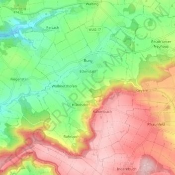
Name: Ettenstatt topographic map, elevation, terrain.
Average elevation: 1,660 ft
Minimum elevation: 1,316 ft
Maximum elevation: 2,047 ft
Other topographic maps
Click on a map to view its topography, its elevation and its terrain.
Möhren
Duitsland > Beieren > Landkreis Weißenburg-Gunzenhausen > Treuchtlingen
Möhren, Treuchtlingen, Landkreis Weißenburg-Gunzenhausen, Beieren, 91757, Duitsland
Average elevation: 1,614 ft
Langlau
Duitsland > Beieren > Landkreis Weißenburg-Gunzenhausen > Langlau
Langlau, Pfofeld, Gunzenhausen (VGem), Landkreis Weißenburg-Gunzenhausen, Beieren, 91738, Duitsland
Average elevation: 1,440 ft